

MINERAL WATER TRAIL
![]()
Romania
Trail presentation
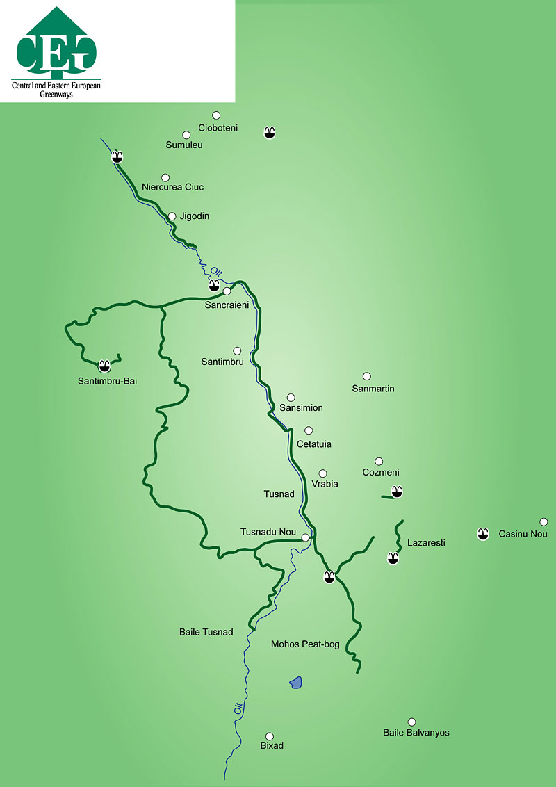
The MWT was inaugurated in 2004 and continues to be developed. The trail runs through the Ciuc River basin in the heart of the Eastern Carpathians, linking mineral water springs. The region boasts more than 2000 sparkling mineral water springs. The main trail is between Miercurea-Ciuc (city) and Tusnad Bai (spa town). The trail is signposted and runs through several agricultural villages along the Olt River. The backbone trail is linked to several local loops. Six mineral water spas have been reconstructed by landscape architects working with local community leaders and using local materials. The greenway provides access to interesting cultural heritage sites, as well as several protected areas and wetlands.
Main tourist attractions and towns along this trail (nature and cultural heritage)
In Miercurea – Ciuc (city):
- two spas with open air and indoor (with thermal mineral water) swimming pools
- Miko castle built in the XVth century;
- Nagy Imre art gallery;
- Grey friars church built from 1802 over a period of 75 years, with one of the biggest wooden statues of the Virgin Mary;
In Sancraieni:
- Borsaros spa with a swimming pool, picnic area;
- protected area with glacier relict plants;
In Tusnad Sat:
- Mineral Water Museum;
- Nyires spa and protected area;
In Cozmeni:
- Soszek spa
- with mineral water pool and outdoor saline bath;
- gothic church;
In Lazaresti:
- Nyir spa;
- one of the richest in mineral water springs in the region and includes more than 50 mineral water springs;
In Tusnad Bai:
- spa,
- Hawk stone protected area;
- Saint Anna's Lake – the only crater lake in Central and Eastern Europe
- Mohos peat bog protected area with glacier relicts
General characteristic of the Greenway
The MWT can be accessed from Miercurea Ciuc and Tusnad Bai. The starting point is on the north side of Miercurea Ciuc by the Olt river bridge. The end of the backbone trail is at the Mineral Water Museum in Tusnad.
Geographical reference mark (major access points/start/end of a greenway)
- Length: the backbone trail is 26 km with 7 marked loops which are between 12 and 40 km long;
- Surface: unpaved field road
- percentage of trail/forestry roads 80% /service roads 10% /quiet roads backbone trail or theme loop
- Main users: cyclists.
- Inter-modality possibilities (connections to closest cities/towns and options for using public transport train/bus): Villages lying along the backbone trail are also connected by train and bus.
- relevant web sites or links: http://www.cfr.ro/, http://www.tusnadfurdo.ro/en/
http://www.geocities.com/csikszentimre/hu/meniu.html
http://www.csikszentkiraly.ro/
http://www.budosfurdo.ro/
http://www.balvanyos.proturism.ro/szentanna.html
http://www.erdelyiturizmus.hu/
Available maps and guidebooks
Local guidebook with description of the loops and local cultural and natural heritage (available in Hungarian).
Contact to Trail Organization
Romanian Environmental Partnership Foundation (contact in Hungarian, Romanian, English)
530151 Miercurea Ciuc str. Harghita nr.7/A/6 Romania
Tel: 0040-266-310678; office@fpc.topnet.ro
http://www.borvizut.ro/, http://www.greenwaz.ro/
Csik County Natura and Tourism Association (contact in Hungerian, Romanian, English)
Miercurea Ciuc str. Inimii nr. 3/14
cstte@nextra.ro